
Drawing Start Point and Necessary Point
In the route design process, you can manually draw points in GIS as route start point and necessary point.
- Click the project in the Project pane.
-
Click the draw and measure icon
 in the
toolbar menu, choose Draw, and click
Point.
in the
toolbar menu, choose Draw, and click
Point.
- Click in GIS. The point is marked.
- Click the Save button. The New window opens.
- Select the type as Route Start Point or Route Necessity Pointer.
-
Input the point name.
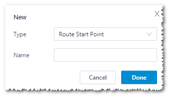
- Click Done to add a point object in the project tree.
- Select the newly created start point or necessary point in Project tree, and open the operation pane.
- Click the Property tab, and modify the name, description and coordinate of the point.
- Click Save to save the changes.