
Calibration
Two sections are included in calibration, declination and shading, for elimination of wind speed errors that might occur in calculation. Refer to Greenwich knowledge center for more details.
-
Click the expand icon
 beside Calibration in operation pane.
- Click the Configuration button beside Declination. The declination page opens.
-
Set up the longitude, latitude, altitude, calibration mode, and erection time of mast.
A calibration mode is recommended as the default according to the mast parameter. You may select one manually from IGRF12 and WMM2015.
- Click the Calculate Magnetic Declination Angle button. The Degree field shows the declination angle to be corrected.
- After confirmation, click the Apply button to add the declination parameters in operation pane.
- Click the Configuration button beside Shading. The Shading page opens.
-
Select the wind speed sensor channel for correction.
Note: Generally, select two sensor channels at the same height.
- Select wind direction sensor.
- Define the time range.
-
Click the Calculation button.
- After calculation, the mast shade graph is displayed at the right side
of this page, showing the wind speed distribution of sensor channel 1
and 2.
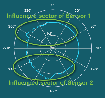
The concave section is a result from wind speed reduction due to mast shade in sensor channel 1, and data in sensor channel 1 should be corrected. The convex section is a result from mast shade in sensor channel 2, and data in sensor channel 2 should be corrected.
- The Angle area displays recommended angles for mast shade correction.
The wind speed between start and end angles of sensor channel 2 are used for correction of that between start and end angles of sensor channel 1.
You can modify the recommended angles manually.
- After calculation, the mast shade graph is displayed at the right side
of this page, showing the wind speed distribution of sensor channel 1
and 2.
-
Click the Apply button to add the shading parameters in operation pane.
Note: If you want to delete a declination or shading calibration result, click
 . The message Delete successful pops up indicating the corresponding result is deleted.
 -
Click the Apply button in the declination or shading area, the calibration is applied.
The wind speed data in sensor channel 2 are used for correction of that in sensor channel 1.
If you want to cancel all the applied calibrations, click the Cancel button.