
Drawing a Line
Line is mainly used for route design. Open the drawing toolbar menu before drawing.
- Click Line in the drawing panel.
- Click two or more points in GIS. The line is drawn successfully.
- Double-click to finish drawing. The double-clicked point is taken as the end point of line.
-
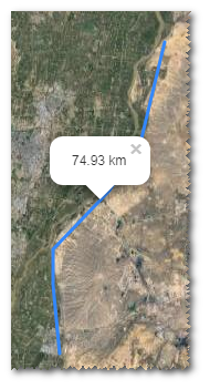
Click the polyline to show its length.
The points clicked is displayed as control nodes
 in GIS.
Transparent control nodes are added between every two control nodes. These
control nodes are used for changing the location and shape of line.
in GIS.
Transparent control nodes are added between every two control nodes. These
control nodes are used for changing the location and shape of line. - Drag the control nodes to change the location and shape of line.
- Select the project name in the project tree.
-
Click the Save button to open the
New window.
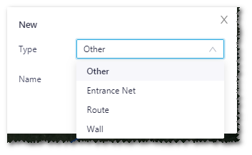
- Select type, and input a name for the line.
- Click the Done button to save the line.